A Challenging Hike with Stunning Summit Views
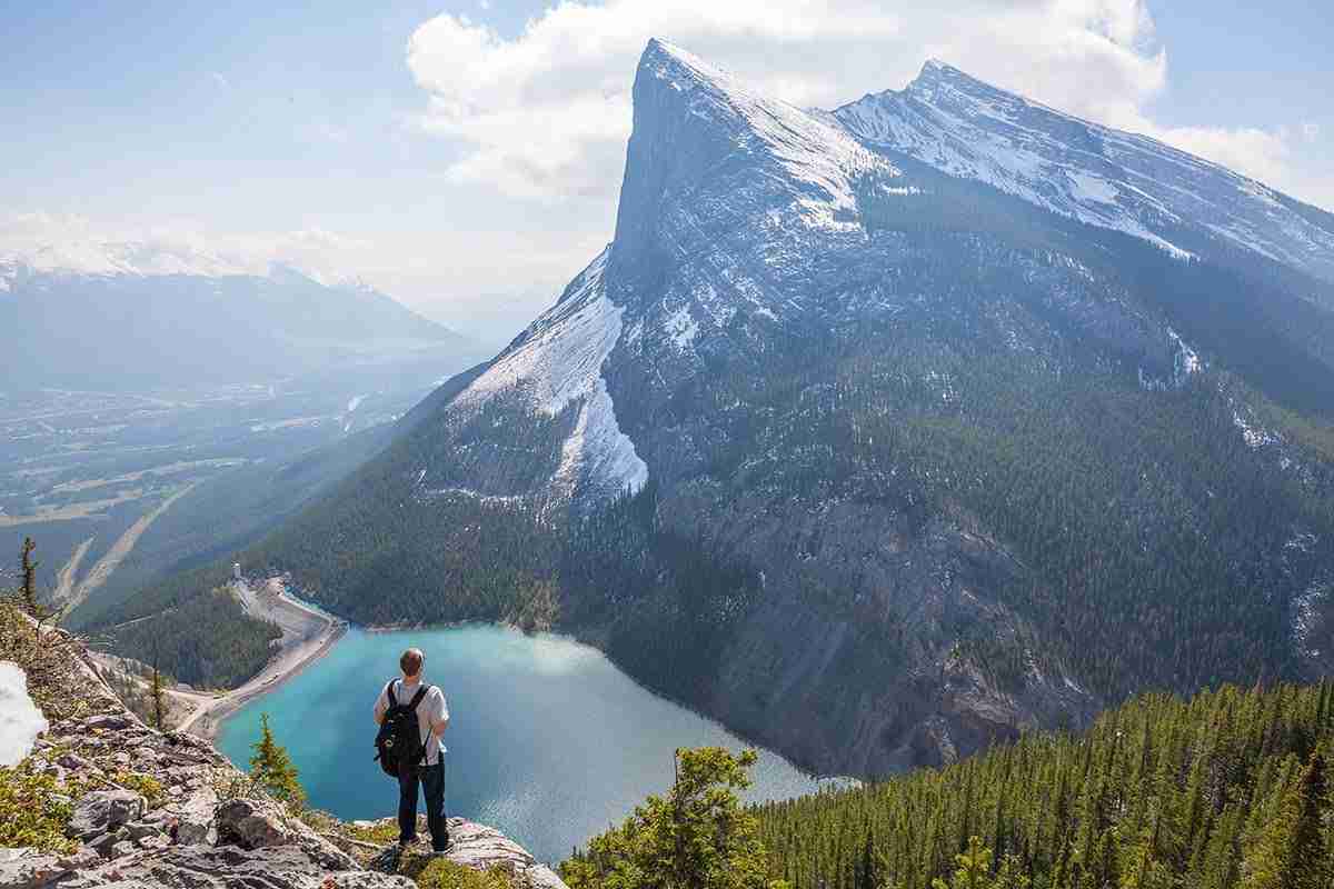
The East End of Rundle, commonly known as EEOR, is a spectacular yet demanding hike in Spray Valley Provincial Park that rewards adventurers with some of the most breathtaking views in the Canadian Rockies. This 5.6 km (3.5-mile) out-and-back trail climbs steeply up the easternmost section of Mount Rundle, offering panoramic vistas of the surrounding mountain ranges and the striking turquoise waters of Whiteman's Pond below. The ascent is strenuous, featuring steep inclines, loose scree, and several sections where scrambling with hands is necessary. Despite the physical challenge, the payoff at the summit is extraordinary, with sweeping views over Canmore, the Bow Valley, and Spray Lakes, making this a dream destination for photographers and hiking enthusiasts alike.
Best Views & Photography Spots
• Whiteman's Pond Overlook – Early in the hike, you'll get fantastic elevated views of this glacial-fed lake with its deep blue-green waters framed by rugged cliffs.
• Rocky Ridges & Alpine Scenery – As you ascend, jagged ridges and dramatic rock formations provide excellent foreground elements for dynamic landscape shots.
• Summit Panoramas – The true highlight of EEOR is the summit, offering unparalleled 360-degree views of Canmore, Ha Ling Peak, Mount Assiniboine in the distance, and the vast Bow Valley below.
Best Time to Hike & Photograph
The EEOR trail is best tackled between May and October, when conditions are safer and more stable. Snow and ice can persist into late spring, making the ascent treacherous, so hikers should check local trail conditions before heading out. Sunrise and sunset hikes offer the most dramatic lighting, casting golden hues across the peaks and valleys. Midday visits provide the brightest reflections on Whiteman's Pond, though the harsh light can create strong contrasts.
Logistics & Hiking Tips
• Trailhead & Parking: The trail begins off AB-742 (Smith-Dorrien/Spray Trail) near Whiteman's Pond. Parking is limited, so arriving early is recommended.
• Difficulty & Preparation: The hike is rated difficult due to its steep elevation gain (870m/2,854ft) and scrambling sections. Proper hiking boots, trekking poles, and gloves are highly recommended.
• Safety Considerations: The area is prone to quick weather changes, and wind conditions can be extreme at the summit. Hikers should carry layers, plenty of water, and bear spray, as this is active grizzly territory.
Nearby Photography Locations
For those looking to extend their photography adventure, other must-visit locations nearby include:
• Ha Ling Peak – Another steep but rewarding summit across the valley from EEOR, providing iconic views over Canmore.
• Spray Lakes Reservoir – A vast mountain lake offering incredible sunrise reflections of the surrounding peaks.
• Grassi Lakes – A short but scenic hike leading to brilliantly colored turquoise lakes, perfect for capturing vivid water tones.
• Canmore Townsite – A charming mountain town with historic streets, mountain backdrops, and excellent sunrise photography spots.
Comments
Loading comments…