
Gerry Point Park sits along the outer edge of Richmond where the Fraser River meets the Strait of Georgia. The park occupies a broad stretch of open shoreline with views across the water toward the distant mountains of Vancouver Island and the Gulf Islands. Instead of dramatic cliffs or dense forest, the landscape here is defined by open sky, long gravel beaches, tidal flats, and grassy fields shaped by steady coastal winds. This simplicity makes the area particularly appealing for photographers who enjoy working with wide horizons, shifting light, and layered coastal scenes. As the tides move in and out across the shoreline and the sky changes throughout the day, Gerry Point Park offers a calm but constantly changing environment for landscape photography.
Best Photography Opportunities
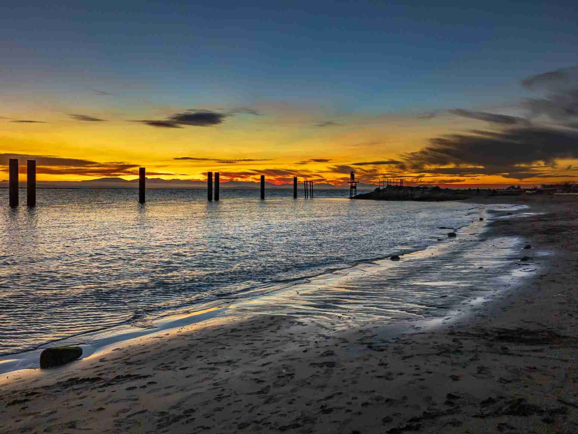
• Gerry Point Lookout – This small viewpoint provides one of the best perspectives across the Strait of Georgia. From here photographers can capture wide ocean views with distant islands and mountain silhouettes along the horizon. The open nature of the landscape allows the sky to become a major element in compositions, especially during sunrise or sunset when clouds often catch color above the water. Including the shoreline in the foreground can help anchor the image and guide the viewer toward the distant horizon. Clear days can reveal distant mountain ranges across the water, adding depth and scale to otherwise simple coastal scenes.
• Tidal Shorelines – The shoreline at Gerry Point Park consists largely of gravel and small stones rather than sand, which creates interesting textures in the foreground. During low tide the waterline retreats and reveals broader areas of exposed shoreline that can be used to frame the ocean and sky. Photographers can position themselves close to the ground to emphasize the textures of the rocks while allowing the horizon to stretch across the upper part of the frame. Waves here tend to be gentle, which makes it easier to capture subtle patterns created by the water along the shore. These quieter compositions often work well in softer light when reflections and surface textures become more visible.
• Drone Photography Over the Area – Aerial photography reveals the geographic setting of Gerry Point Park in a way that is difficult to appreciate from ground level. From above, the meeting point between the Fraser River and the open waters of the Strait of Georgia becomes much more visible. Drone images can capture the long curves of shoreline, tidal channels, and the shape of the park extending into the water. Flying slightly offshore can help frame the coastline with the surrounding water and distant mountains beyond. As always, photographers should check local regulations and airspace rules before flying and operate responsibly around other park visitors and wildlife.
• Coastal Grasslands – Behind the shoreline, the park contains open grassy areas that create simple but effective foregrounds for landscape photography. These fields often sway in the wind, adding a sense of movement when photographed with slower shutter speeds. The grasses also help break up the flat horizon line by introducing subtle textures and color variation into the foreground. Photographers can use these areas to frame wide sky compositions where the landscape becomes a smaller element beneath expansive cloud formations. During late afternoon light the grasses often take on warmer tones that contrast with the cooler colors of the water.
• Sunset Reflections – Gerry Point Park faces west toward the Strait of Georgia, which makes it an excellent location for sunset photography. As the sun lowers toward the horizon it reflects across the water and creates bands of color that stretch toward the shoreline. Photographers can capture these reflections from the gravel beach or from slightly elevated points within the park. Calm evenings sometimes produce smoother water conditions that allow the colors of the sky to spread gently across the surface. Watching the sky after the sun dips below the horizon can be especially rewarding since the colors often intensify for several minutes afterward.
Best Time to Visit
Sunset is typically the most rewarding time to photograph Gerry Point Park because the shoreline faces directly west across the Strait of Georgia. As the sun sets over the water it often produces warm colors that reflect across the ocean and illuminate the surrounding clouds. Even on evenings without dramatic clouds, the open horizon allows for clean and minimal sunset compositions.
Spring and autumn can provide especially good conditions when shifting weather patterns bring changing skies and dramatic cloud formations. Winter often offers clearer air, which can make distant mountain views across the water appear sharper. Photographers interested in tidal shoreline compositions should check local tide charts before visiting, since lower tides expose more of the textured shoreline. Wind is common along this exposed stretch of coast, so calmer evenings can make tripod work and long exposures easier.
How to Get There
Gerry Point Park is located in Richmond, British Columbia, near the southwestern edge of Lulu Island. The park sits close to the mouth of the Fraser River where it opens into the Strait of Georgia. Parking is available near the park entrance, and several walking paths provide easy access to the shoreline and lookout areas. The park is relatively flat, making it simple to move between viewpoints while carrying camera gear.
Public access to the park is generally free, though parking rules may apply depending on the season or time of day. The walking paths around the shoreline allow photographers to explore different angles along the coast while remaining close to the main access points.
Recommended Photography Gear
Because Gerry Point Park is defined by wide horizons and expansive sky, a wide lens is particularly useful for capturing the full scale of the coastal landscape. This type of lens works well for emphasizing foreground textures along the gravel shoreline while still including the distant horizon and sky. A mid range zoom lens can also help isolate distant islands or mountain silhouettes across the Strait of Georgia.
A tripod is valuable for photographers who want to capture sunset colors using longer exposures. Neutral density filters can help extend exposure times when photographing moving water or clouds during brighter conditions. A circular polarizing filter is also useful for reducing glare on the water and deepening the color of the sky. Since the park is exposed to strong coastal winds, bringing a sturdy tripod and protective gear for camera equipment can help maintain stability and protect against blowing sand or spray.
Nearby Photography Locations
• Steveston Harbour
is a busy fishing port filled with working boats, docks, and maritime activity. Photographers can capture scenes of fishing vessels returning with their catch or quiet moments along the harbor during early morning light. The mixture of boats, water reflections, and coastal buildings creates a different style of subject compared to the open landscapes of Gerry Point Park.
offers a completely different environment with farmland fields, walking trails, and views across the Fraser River toward Vancouver. The open agricultural landscape creates interesting foreground textures with crops, grasses, and farm structures. During sunset the light often spreads across the fields and river, producing warm tones that work well for wide landscape compositions.
preserves several old wooden buildings that once supported the fishing industry in the region. The structures sit along the river and provide strong architectural subjects alongside maritime scenery. Photographers can capture reflections of the buildings in the water or focus on the textures and details of the historic structures.
runs along the outer edge of Richmond and offers long views across tidal marshes and open water. The raised pathway provides elevated perspectives across the wetlands where birds and coastal wildlife are frequently seen. Sunrise and sunset light often create soft reflections across the water channels within the marsh.
extends far into the Strait of Georgia along a long jetty that leads toward the outer coastline. The straight pathway creates strong leading lines that draw the viewer toward the horizon. Photographers can capture expansive ocean views and distant mountain silhouettes from one of the longest walkable jetties in the region.
Comments
Loading comments…