Nestled deep within the forested highlands near Ompah, Ontario, Heart Lake is a naturally occurring spectacle that earns its name from a perfectly organic heart-shaped basin, best appreciated from the sky. While on the ground it's hidden by dense forest and rugged terrain, from above, the lake reveals itself in dramatic fashion—especially in autumn, when the surrounding landscape erupts in a kaleidoscope of reds, oranges, and golds. For drone photographers, it's a rare combination of shape, color, and natural symmetry that turns a single frame into an unforgettable visual signature. But this is not a location for casual exploration; it demands respect—for the land, the residents, and the environment. With planning, patience, and a lightweight aerial setup, Heart Lake is among Ontario's most rewarding hidden gems.
Best Photography Opportunities
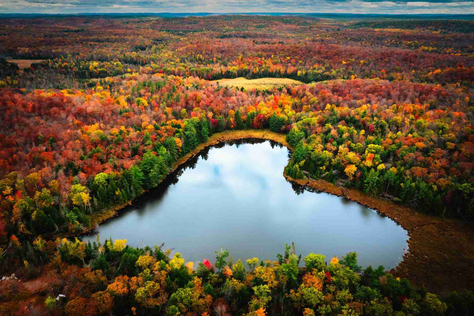
• Aerial View of the Full Heart Shape
: The signature shot here is, of course, a top-down composition that captures the entire lake and its unmistakable heart shape. A drone equipped with a wide-angle lens (24mm equivalent or wider) and a high-resolution sensor (20MP or more) will allow you to frame the lake cleanly while preserving foliage detail. The best altitude is around 90–120 meters, balancing scale with clarity. Early morning flights often benefit from mist lingering along the forest edges, adding atmosphere and subtlety to the scene.
• Autumn Canopy and Color Gradients
: During peak fall color—typically late September to early October—the dense maple and oak forests surrounding Heart Lake shift into full vibrancy. Use oblique angles to capture the edge of the lake surrounded by fiery hues, with the treetops forming gradients from deep crimson to golden yellow. These shots work well with side lighting in the late afternoon, which adds dimensionality and highlights the contours of the terrain.
• Reflection and Sky Balance at Low Altitude
: When conditions are calm, the lake surface mirrors the surrounding trees with crystal clarity. Flying lower (20–30 meters) at a slight angle, you can create a dual-layer composition with the forest and its mirrored image converging toward the lake's tip. Use an ND filter to reduce shutter speed slightly for smoother reflections and adjust the polarizer to manage surface glare.
• Seasonal and Textural Detail Studies
: Beyond the iconic heart shape, Heart Lake offers excellent opportunities for seasonal studies of forest texture and density. Tight crops using a zoom-equipped drone can isolate pockets of color contrast, fallen trees, or shoreline transitions between evergreen and deciduous forest. These images make excellent abstracts or secondary compositions for a complete series.
• Framing the Hydro Line and Access Route
: While the lake itself remains the focal point, photographing your access route—particularly the rugged Hydro line corridor and its vanishing-point utility towers—can help tell the story of the journey. These utilitarian lines cut striking diagonals through the wild landscape and serve as strong compositional tools for secondary narrative shots.
Best Time to Visit
The ideal window for photographing Heart Lake is during Ontario's fall color peak, typically between the last week of September and the first two weeks of October. During this time, the foliage is at its most vibrant, and the light is low and golden for longer periods, especially around sunrise and sunset. The area receives minimal light pollution, making early morning fog and twilight conditions particularly compelling for atmospheric aerial shots.
Wind tends to pick up mid-morning in the autumn, so plan to fly shortly after sunrise for the calmest air and softest light. Summer visits are possible, but the full impact of the lake's shape can be diminished by the uniform green canopy. Winter flights are technically feasible but can obscure the lake's outline with snow and ice, making the defining heart shape harder to capture.
Avoid flying during high winds or precipitation—this is a remote area with no infrastructure nearby, so safety and equipment protection must be top priority. Always check weather conditions in advance and aim to fly within the most stable windows of daylight.
How to Get There
Heart Lake lies northeast of Ompah, Ontario, within an undeveloped patch of crown land. Though the lake itself is not privately owned, surrounding properties restrict direct access on foot. Locals have made it clear that trespassing through their land is not tolerated, and respecting these boundaries is essential.
To access a viable launch point for drone photography, navigate to Hydro Line Road, a rough, one-lane utility corridor that cuts through the forest near the lake. From the village of Ompah, take River Road northeast until it connects with Hydro Line Road. This track is unpaved, rocky, and often muddy—a high-clearance vehicle or 4×4 truck is strongly recommended.
Scout for a wide pull-off along Hydro Line Road where you can safely park without blocking the path. Ensure your drone has GPS lock and line of sight to Heart Lake, which lies slightly west of the utility corridor. Launch from the clearing and ascend cautiously, watching for tree canopy and signal dropouts in this remote environment.
There are no signs, amenities, or facilities—pack out everything you bring and be prepared for unpredictable terrain. Cell reception is limited, so offline maps and GPS are advisable. No permits are required to fly from crown land, but you must follow Canadian drone regulations and remain at least 30 meters away from people and structures, including any private homes visible on the horizon.
Recommended Gear and Shooting Tips
Use a drone with a high-resolution camera and gimbal stabilization for sharp top-down shots. A model like the DJI Air 2S or Mavic 3 series is ideal, offering both wide coverage and RAW image capability for editing flexibility. ND and polarizing filters help manage harsh light and reflections off the water, while shooting in RAW ensures maximum dynamic range for post-processing subtle autumn tones.
Bring at least two fully charged batteries—cold weather can shorten flight times, and returning for a second pass may not be practical. Fly with a spotter if possible and maintain visual line of sight throughout your session. Avoid extended hovering—plan your compositions in advance and move between positions purposefully to maximize flight time.
Shooting early in the morning will give you the calmest air and best color, while late afternoon light adds warmth and drama. Avoid flying at noon, when top-down light flattens texture and reduces shadow depth. Plan for redundancy: download your footage to a backup device before leaving the area.
Finally, always stay aware of your surroundings—this is active wilderness, and unexpected animal encounters or fast weather changes can impact your shoot. Let someone know where you're going and when you plan to return.
Nearby Photography Locations
• Canonto Lake Lookout
: Just southwest of Ompah, this elevated trail provides a dramatic view over Canonto Lake and surrounding forest. It's particularly beautiful at sunset and is accessible by foot via a short hike through mixed hardwood.
• Mazinaw Rock at Bon Echo Provincial Park
: About 40 minutes south, this towering granite cliff along Mazinaw Lake is home to ancient Indigenous pictographs and dramatic vertical relief. Excellent for drone and ground-based shots, especially during golden hour when shadows define the cliff face.
• Palmerston Lake Public Dock
: A peaceful spot with calm water, island views, and reflections—ideal for long exposures, minimalist landscapes, or drone work over the lake's twisting shoreline. Visit at sunrise for morning mist and vibrant color.
• Crotch Lake Backcountry Access Points
: Known for its rugged campsites and unspoiled shoreline, Crotch Lake offers excellent foreground elements for sunset shots and large panoramic drone compositions with minimal development.
• Centennial Lake and Hydro Dam
: East of Ompah, this location features striking water flow patterns and contrasting industrial structures nestled in raw landscape. It's best photographed from higher elevation or aerial vantage points in the golden hour.
Heart Lake may be hidden from the roads and unreachable on foot, but from the sky, it reveals one of Ontario's most poetic natural designs. With the right preparation, respect for the land, and careful flight execution, drone photographers can capture not only the form of a heart, but the soul of Ontario's backcountry at its most vibrant and untamed.
Comments
Loading comments…